Documentation Organization
AIRS documentation archive
AIRS documentation can be accessed at the Goddard Earth Sciences Data and Information Services Center at:
https://disc.gsfc.nasa.gov/information/documents?title=AIRS%20Documentation
AIRS documentation organization
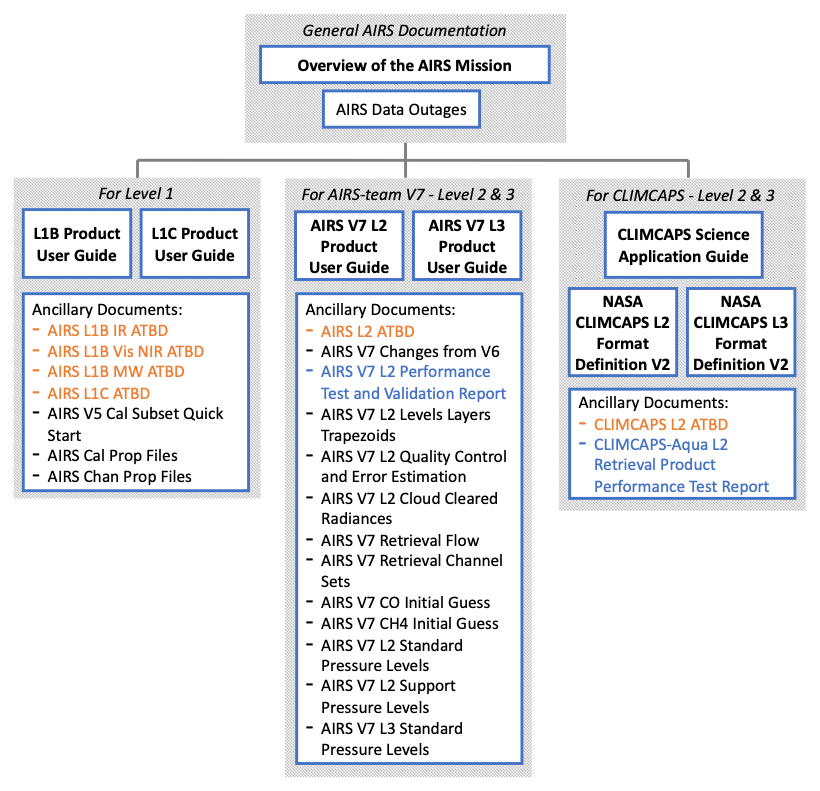
The AIRS documentation is mainly organized according to data processing levels. The available documents are listed in Figure 16 below. Documents are referred to by file names (omitting underscores and file type extensions) that include abbreviated levels (L1B, L1C, L2, L3) and version (V7, V6.7, V5, V2).
The general AIRS overview documentation plus the level-specific product user guides are intended to be the primary source of documentation for most users. Several other ancillary documents are provided that may be important for some users but not for others. For users of Level 2 and 3 data, separate user guides and ancillary documents are provided for the two different retrieval systems, CLIMCAPS and the AIRS-team retrieval.

Figure 16: AIRS documentation. Documents are listed by file name (omitting underscores and file type extensions) and are accessible at the AIRS documentation web page. General documents apply to all AIRS suite products, level-specific user guides are intended for the general user of each level product, and ancillary files contain more specific information. For users of geophysical products, separate documents are provided for AIRS-team V7 products and CLIMCAPS products. Algorithm Theoretical Basis Documents (ATBDs) provided for different levels and retrieval systems in orange font. Test reports for geophysical products are in blue font.
General AIRS Documentation
There are two documents that apply to all AIRS/AMSU/HSB products:
- Overview of the AIRS Mission (the AIRS guide on this site) is designed to provide an overview of AIRS products and orient new and experienced users, giving and pointing to crucial information for data users.
- AIRS Data Outages is a supporting document that provides a history of AIRS suite instrument states and periods where data is unavailable, with short descriptions of the reasons behind the outages (also updated on the AIRS website).
Level 1
The AIRS V5 L1B Product User Guide is a collection of useful information for Level 1B data users. It includes a quick start guide to the most basic quality assurance parameters that can be accessed to judge L1B radiance product quality.
For Level 1C users the AIRS V6.7 L1C Products User Guide is the main document. Several ancillary documents for Level 1 are provided that may not be needed for some users but contain helpful information, particularly for advanced users.
Algorithm Theoretical Basis Documents (ATBDs) describe the theoretical bases of the algorithms used to obtain the different products and are provided for Level 1C and L1B and each instrument type (infrared, microwave, visible/near-infrared).
Files listing various channel properties (AIRS Chan Prop Files) and calibration properties (AIRS Cal Prop Files) for all channels are also provided as sets of zipped files.
AIRS V5 Cal Subset Quick Start contains a discussion of the calibration subset radiance product.
CLIMCAPS Level 2 and Level 3
General material for CLIMCAPS with detailed guides for each key physical variable is provided in The CLIMCAPS Science User Guide. Note that this guide also applies to the CLIMCAPS system for other instrument configurations. Additional details about the CLIMCAPS products, such as file contents, lists of variables and definitions, are provided in level-specific user guide documents; NASA CLIMCAPS L2 Format Definition V2 applies to Level 2 products and NASA CLIMCAPS L3 Format Definition V2 is the equivalent for Level 3. These documents also apply to CLIMCAPS across different instruments and platforms. Initial results of analyses performed by the JPL AIRS Project to assess the general quality of various core products produced by the CLIMCAPS-Aqua retrieval system are presented in the CLIMCAPS-Aqua V2 L2 Retrieval Product Performance Test Report. For CLIMCAPS, an algorithm theoretical basis document (CLIMCAPS L2 ATBD) is provided in the form of a peer-reviewed publication by Smith & Barnet (2019).
AIRS-team V7 Retrieval Level 2 and Level 3
For users of AIRS-team Level 2 retrieval products, the AIRS V7 L2 Product User Guide is the main document. It is organized by geophysical variables, where the material for each product has the same structure and contains references to other relevant documents. For example, a user mainly interested in temperature profiles or ozone products can find most important information in one place in the relevant subsection. A complete list of available fields in the Level 2 data files is provided in an appendix to that document, along with short descriptions.
For users of AIRS-team Level 3 data, the AIRS V7 L3 Product User Guide is the main document. Since Level 3 products are derived from Level 2 products, users may wish to consult Level 2 documentation for further understanding of the products.
Ancillary documents
There are several ancillary documents that apply to the AIRS-team Version 7 release of Level 2 and Level 3 products. The main changes introduced in Version 7 are summarized in AIRS V7 Changes from V6. The AIRS V7 L2 Performance Test and Validation Report further characterizes the differences between Version 6 and Version 7 of AIRS core data products and includes comparisons to other well validated data sources such as radiosondes, surface station, and satellite measurements. It is mostly focused on Level 2 data products but contains limited results for Level 3 products as well. The AIRS V7 L2 Quality Control and Error Estimation document describes the various quality indicators and how they are set. It is recommended for all users to familiarize with at least the general sections of that document, and the variable-specific sections as needed.
Other ancillary documents may not be needed for some users but contain helpful informationfor a subset of users. The AIRS L2 ATBD (Algorithm Theoretical Basis Document) provides the theoretical foundation for the AIRS-team retrieval of geophysical parameters from AIRS, AMSU and HSB radiance observations. AIRS V7 Retrieval Flow provides a brief overview of the steps of the AIRS-team Version 7 retrievals, and a comparison between Version 7 AIRS-Only and AIRS/AMSU, and the Version 6 retrieval system. In AIRS V7 Retrieval Channel Sets, the channels that are used in each part of the AIRS-team Version 7 physical retrieval and the preceding neural network regression are listed by function (geophysical variables).
Vertical representation – Layers and Pressure Levels
AIRS V7 L2 Levels Layers Trapezoids contains a discussion of the vertical representation of AIRS-team Level 2 products. This includes a discussion of levels and layers and procedures to convert between them. Trapezoidal layers are introduced with guidance on how to use averaging kernels to compare AIRS profiles with other profiles. Special considerations regarding the top of atmosphere and the surface in product profiles are also covered. Since some users have difficulty accessing attributes in the data files, tables with the AIRS-team retrieval Level 2 and 3 standard and support pressure levels are provided in separate documents, AIRS V7 L2 Standard Pressure Levels, AIRS V7 L3 Standard Pressure Levels, and AIRS V7 L2 Support Pressure Levels (common to L3).
Cloud-clearing and initial guess
Finally, some documents are provided that provide additional details for specific data products. AIRS V7 L2 Cloud Cleared Radiances contains a discussion of error estimates and suggested quality control for AIRS-team Level 2 Cloud Cleared Radiances. For the CO and CH4 trace gas products, profiles and algorithm to reproduce initial guesses for the AIRS-team retrievals are given in AIRS V7 CO Initial Guess Profiles and AIRS V7 CH4 Initial Guess Profiles.
Additional resources
For additional information, please consult the AIRS public web site:
Questions may also be submitted at the AskAIRS link here:
https://airs.jpl.nasa.gov/data/support/ask-airs
AIRS data users may register here to receive periodic announcements of data features that may impact their research and an occasional newsletter: