Carbon Monoxide
Key Questions
CLIMCAPS retrieves profiles of CO column densities [molecules/cm2] on 100 pressure layers. These are the standard pressure layers used in modern-era radiative transfer models and that CLIMCAPS employs in all its trace gas retrievals. You can integrate column layer densities across any pressure range (e.g., 200–700 hPa) or for the total column (surface to top of atmosphere) simply by adding the retrieved layer densities together. CLIMCAPS retrieves CO from a set of hyperspectral infrared channels selected from cloud cleared AIRS or CrIS radiance measurements in the 2100 cm−1 wavenumber (or 4.7 μm wavelength) range.
How can I access CLIMCAPS CO retrievals?
CLIMCAPS CO retrievals are distributed within the main L2 product file that is generated and archived by the NASA Goddard Earth Sciences Data and Information Services Center (GES DISC).
Which retrievals should I avoid?
Generally, avoid using CLIMCAPS CO retrievals in the boundary layer, tropopause and stratosphere. For atmospheric pressures greater than ~700 hPa and less than ~200 hPa, CLIMCAPS has very low observing capability for CO (see Figure 3 and Figure 4 for more details). We assign a quality control (QC) index for each retrieval that you can use to filter out ‘bad’ retrievals. By far the biggest reason CLIMCAPS retrievals fail is due to clouds covering entire the field of regard. Infrared (IR) radiation is strongly affected by clouds. A top of atmosphere IR radiance of an overcast scene contains no information about the atmospheric state below the scene. In version 2.0, we do not have quality controls set up for CO specifically, but apply the same quality flag to all retrievals. Avoid using CO retrievals from the normal spectral resolution CLIMCAPS-SNPP system, since CrIS spectral resolution in CO absorption region is too low to accurately detect CO.
How do I interpret CO retrievals in cloudy or smoky regions?
CLIMCAPS performs cloud clearing on all field of regards where clouds were detected to allow retrievals past the clouds. CO retrievals at the edges of clouds, where the scene is partly cloudy, are reliable representations. Usually CO retrievals are marked ‘bad’ when a smoke plume covers the entire field of regard and affects IR radiances as if they were opaque cloud fields.
Which type of applications are CLIMCAPS CO good for?
We recommend that you use CLIMCAPS CO products for long-range pollutant transport (Smith et al. 2020) and assimilation into chemistry models. We advise against using CLIMCAPS CO retrievals in air quality applications or urban-scale monitoring. Use CLIMCAPS CO for regional or global monitoring to flag regions for analysis with final scale measurements and products.
1. Overview
It is relatively easy to measure CO with IR instruments from space because CO has a distinct spectral signature in the 2100 cm−1 wavenumber range. CLIMCAPS selects a subset of these channels from AIRS on Aqua and CrIS on SNPP and NOAA-20 to retrieve CO after retrieval of clouds, temperature, moisture and ozone. IR spectral channels are highly correlated signals about multiple atmospheric state variables, so even those channels that are sensitive to CO specifically are also sensitive to other variables, albeit to a lesser degree. In CLIMCAPS, we attempt to quantify and propagate most sources of uncertainty to make CO retrievals as robust as possible (Smith and Barnet, 2019, 2020).
CLIMCAPS calculates an averaging kernel matrix for every CO retrieval and writes this to the product file. CLIMCAPS averaging kernels are unique to each retrieval variable at each field of regard and can be used to evaluate the sensitivity of the retrieval system to the true state of the atmosphere, as ‘signal-to-noise’ or ‘information content’ metrics. The trace of the averaging kernel matrix is known as the ‘degrees of freedom for signal’ (DOF) and quantifies the number of independent pieces of information CLIMCAPS has about CO in the vertical atmospheric column at any given point in time and space. In Figure 1 below we plot CLIMCAPS CO DOF for the ascending orbits (13h30 local overpass time) of SNPP on 1 April 2016 to illustrate its spatial variation (high values in Northern hemisphere, with very low values in Southern Polar region (< 60°S). CLIMCAPS CO DOF varies daily and seasonally.

Figure 1: CLIMCAPS-SNPP degrees of freedom (DOF) for CO at every retrieval scene from ascending orbits (01:30 PM local overpass time) on 1 April 2016. DOF is an information content metric and quantifies how many pieces of information (or distinct vertical layers) CLIMCAPS can retrieve about CO at every scene. For most of the globe, CLIMCAPS has CO DOF of ~1. We used the netCDF field co_dof and did not apply any quality filtering since DOF is not affected by retrieval outcome.
Note in Figure 1 that CLIMCAPS maintains a fairly consistent pattern of CO DOF between 0.9–1.0 with values falling below 0.5 in the South Pole. A DOF ≈ 1.0 means that CLIMCAPS is sensitive to CO in a single vertical layer. A DOF ≈ 2.0 would indicate sensitivity to two vertical layers and so on. How should we interpret a DOF < 0.5? This means CLIMCAPS has very low observing capability of CO at that site and the retrieval contains mostly a-priori information and measurement uncertainty. In Figure 3 and Figure 4 below we have a closer look at the vertical bounds of this single layer of CO sensitivity.

Figure 2: Global map of CLIMCAPS-SNPP retrieved CO tropospheric column density. CLIMCAPS retrieves CO on 100 pressure layers as column density, or number of molecules per cm2. Here we integrated all retrieved layers between 200–700 hPa to given an estimate of the mid-tropospheric CO load. We used the netCDF field mol_lay/co_mol_lay, integrated each profile into a tropospheric column density and filtered out all retrievals where their corresponding aux/ispare_2 value was equal to one.
CLIMCAPS uses a static climatology as a-priori (also referred to as the first guess or background estimate) to retrieve CO from a subset of cloud-cleared IR radiance channels. This climatology consists of two profiles—one for the Northern and another for the Southern Hemisphere—to account for the strong latitudinal gradient in CO concentrations. CO also has seasonal variation due to the seasonality in biomass burning regimes from different parts of the world, which the CLIMCAPS climatology reflects by having two profiles (North vs South) for each month of a year, thus 24 in total (see Section 2.2 for more details). We need to understand this to correctly interpret Figure 2. All the spatial variation in CO column density for this day, 1 April 2016, from West to East thus results from the IR measurements (information content and noise) and retrieval system design (e.g., uncertainty quantification and propagation) alone, not the background estimate used as a-priori.
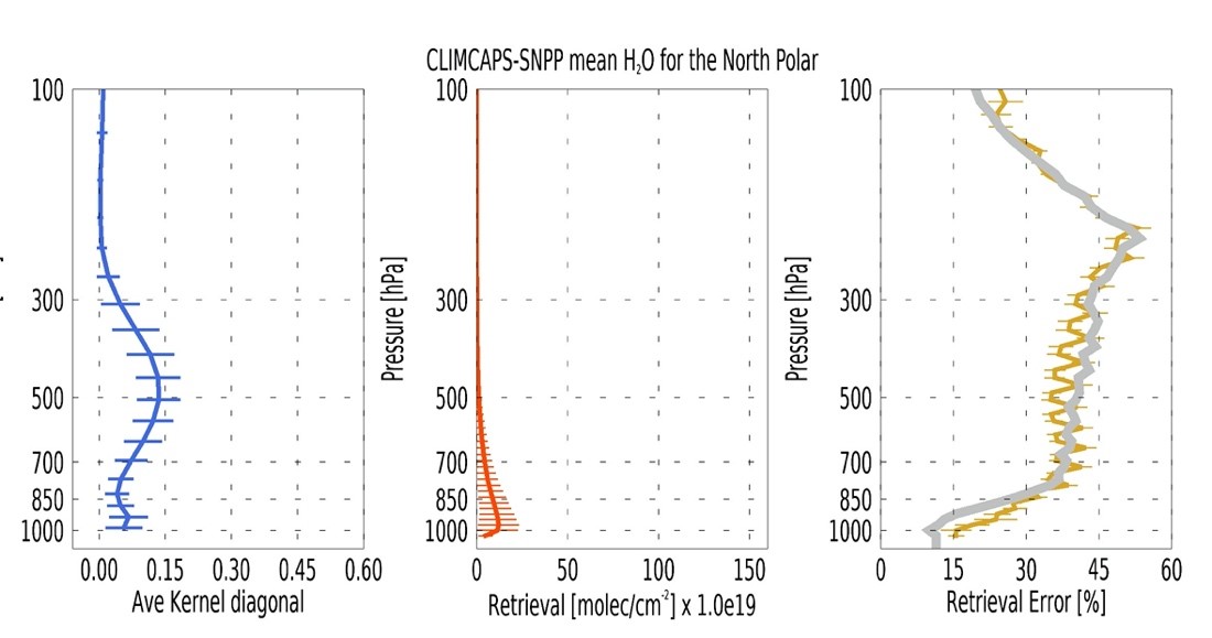
In Figure 3 and Figure 4 we take a closer look at CLIMCAPS averaging kernels, CO profile retrievals and their associated errors. We plot these for CLIMCAPS retrievals from the full spectral resolution SNPP system on 1 April 2016. Figure 3 shows the mean profiles (with standard deviation error bars) for the North Polar region (> 60°N), and Figure 4 for the Tropics (30°S to 30°N). We used the diagonal vector of the averaging kernel matrix as representation of the maximum sensitivity at each pressure layer.
The blue line (Figure 3 and Figure 4) is the mean of the diagonal vectors. Note how there are fewer vertical error bars on the blue line compared to the retrieval (orange line) and error (yellow line) profiles. This is because CLIMCAPS averaging kernels are calculated on a reduced set of pressure layers, defined by a series of overlapping trapezoids. The retrieval and its error is calculated on 100 pressure layers because the radiative transfer model (SARTA) requires high vertical definition to calculate top of atmosphere IR radiances accurately.
Note how the averaging kernels show that CLIMCAPS has maximum sensitivity to CO broadly around 500 hPa. The closer an averaging kernel gets to zero, the more CLIMCAPS reproduces the a-priori without any information added by the measurements. Using a threshold of ~0.1, we see that CLIMCAPS has sensitivity to CO within the vertical layer roughly from 200 hPa to 700 hPa. These are also the pressure bounds we used in calculating column density in Figure 2. The averaging kernel decreases sharply from 700 hPa to the Earth surface, which we interpret as CLIMCAPS having weak sensitivity to CO in the boundary layer. This means that CLIMCAPS does not have the ability to observe and monitor CO concentrations of interest to air quality forecasters, i.e., in the boundary layer air we all breathe every day.
CLIMCAPS does, however, have the ability to observe CO concentrations in the mid-troposphere, and to do so over long distances day and night over the course of weeks, or for as long as CO concentrations are high enough to affect IR absorption lines at the top of atmosphere. We wrote about this capability for the CLIMCAPS sister system that runs in real-time at NOAA, namely NUCAPS, in an AMS paper (Smith et al. 2020).
![Figure 3: A diagnosis of CLIMCAPS-SNPP CO retrievals for the North Polar latitudinal zone [>60°N] on 1 April 2016.](https://airs.jpl.nasa.gov/data/guides-docs/climcaps-science/climcaps-science-guide/figure-3.jpg "Figure 3: A diagnosis of CLIMCAPS-SNPP CO retrievals for the North Polar latitudinal zone [>60°N] on 1 April 2016.")
Figure 3: A diagnosis of CLIMCAPS-SNPP CO retrievals for the North Polar latitudinal zone [>60°N] on 1 April 2016. Each solid line represents the mean zonal profile and error bars the standard deviation at each pressure layer. [left] CLIMCAPS CO averaging kernel matrix diagonal vector from netCDF field ave_kern/co_ave_kern that indicates the pressure layers at which CLIMCAPS has sensitivity to the true state of CO in the atmosphere. [middle] CLIMCAPS CO profile retrieval from netCDF field mol_lay/co_mol_lay [molec/cm2]. [right] CLIMCAPS retrieval error from netCDF field mol_lay/co_mol_lay_err [molec/cm2] represented here as percentage [mol_lay/co_mol_lay_err]/[ mol_lay/co_mol_lay]⁎100. CLIMCAPS uses a CO a-priori error of 40% as represented by the thick grey line. A Bayesian Optimal Estimation retrieval system (like CLIMCAPS) typically reduces the a-priori error in all successful retrievals, In calculating these mean profiles, we filtered out all retrievals where aux/ispare_2(i,j) = 1. We plot these profiles using the pressure layer array called air_pres_lay.
![Figure 4: A diagnosis of CLIMCAPS-SNPP CO retrievals for the Tropical zone [30°S to 30°N] on 1 April 2016.](https://airs.jpl.nasa.gov/data/guides-docs/climcaps-science/climcaps-science-guide/figure-4.jpg "Figure 4: A diagnosis of CLIMCAPS-SNPP CO retrievals for the Tropical zone [30°S to 30°N] on 1 April 2016.")
Figure 4: The same as Figure 3 but for the Tropical zone [30°S to 30°N].
Figure 4 shows that CLIMCAPS retrieves a higher variability in CO for the Tropics, which also corresponds to the stronger sources of CO in this latitude zone. The retrieval error we depict in the righthand panel (yellow line) of Figure 3 and Figure 4 represents the diagonal vector of the a-posteriori error covariance matrix that CLIMCAPS generates for each retrieval variable at each field of regard. This error profile in the netCDF file (mol_lay/co_mol_lay_err) is in the same units [molec/cm2] as the retrieval profile (mol_lay/co_mol_lay) so we could easily calculate the error as a percentage by dividing the error by the retrieval, multiplied by 100. This error does not represent the accuracy, bias, or error with respect to the true state, but instead is a representation of how much CLIMCAPS improved upon the a-priori error estimate.
CLIMCAPS defines a 40% error for its climatological a-priori, which we indicate by the thick grey line in the righthand panels of Figure 3 and Figure 4. Here we see that CLIMCAPS reduces the a-priori error to ~30% within the pressure layers defined by the averaging kernel. You can use this error estimate as a sanity check to see whether the CLIMCAPS system reduced uncertainty in the climatological background knowledge of CO by adding information from IR measurements at that scene.
If the a-posteriori error (also referred to as the ‘retrieval error’) exceeds the a-priori error (which is 40% at every retrieval footprint) at any given pressure layer or retrieval scene, then we can interpret it as the retrieval system being dominated by uncertainty for the target variable, given system design criteria such as channel selection, regularization parameters and uncertainty quantification.
In Figure 4, we see this happening for some scenes in the Tropics at ~900 hPa (right panel, yellow error bar) where the information content also approaches zero (left panel, blue error bar). The a-posteriori error is a typical by-product of all systems using the Rodgers (2000) OE retrieval method.
2. Preparing CLIMCAPS CO retrievals for applications
2.1 Boundary layer adjustment
CLIMCAPS uses a standard 100-layer pressure grid to retrieve atmospheric variables from Earth surface (1100 hPa) to top of atmosphere (0.005 hPa). This pressure grid is required by radiative transfer models (SARTA for CLIMCAPS) to accurately calculate top of atmosphere hyperspectral IR radiances. CLIMCAPS uses the exact same pressure grid at every scene on Earth and accounts for surface pressure as a separate variable during radiative transfer calculations. The retrieved profiles are, however, reported on the 100-layer grid as a means to standardize the output. It is important that you adjust the bottom layer, i.e. that pressure layer intersecting the Earth surface as identified by air_pres_lay_nsurf in the CLIMCAPS netCDF file, to accurately reflect the total number of CO molecules in the boundary layer.
You should do this boundary layer adjustment if you calculate total column densities or if you assimilate vertical profile retrievals. We describe the method for doing this adjustment in detail elsewhere.
This boundary layer adjustment is less relevant if you work with CO retrievals in the mid-troposphere, above the boundary layer such as depicted in Figure 2.
2.2 CO a-priori
The CLIMCAPS netCDF file does not have a field for the CO a-priori. CLIMCAPS uses a static climatological CO mixing ratio [ppb] a-priori that it interpolates latitudinally and for ‘day-of-the-month’ at run time. If your application depends on knowledge of the CO a-priori, e.g., data product assimilation and diagnostic comparisons, then you need to know how to calculate the CO a-priori for the retreival scenes you are interested in.
CLIMCAPS CO a-priori is based on a 12-monthly climatology of two CO profiles per month from the Measurement of Pollution in the Troposphere (MOPITT; Drummon and Mand, 1996) instrument, which is onboard the Terra satellite. The two profiles represent the Northern Hemisphere (NH; >15°N) and Southern Hemisphere (SH; <15°S), respectively. In total there are, thus, 24 climatological CO profiles as baseline that capture seasonal variability in the two Hemispheres (Figure 5).
At runtime, and to avoid a sharp latitudinal break in the global representation of CO, CLIMCAPS performs a spatial interpolation between 15°N and 15°S (Figure 5) to introduce a gradual transition between North and South. This is necessary because there is a large difference in the mean background state between North and South in any given Month.
When we plot these 12 climatological CO profiles for each hemisphere as a ‘curtain plot’ of month versus pressure [hPa] then we see the seasonal variation in each Hemisphere emerge (Figure 6). This seasonal pattern in CO concentrations are confirmed by in-situ measurements (Té et al., 2016). The NH experiences a maximum in tropospheric CO during March and April, and a minimum in October. The SH has a smaller amplitude in its seasonal cycle and experiences its peak CO concentrations in October and November.

Figure 5: CLIMCAPS CO a-priori for the Northern and Southern Hemispheres for twelve months to capture seasonal variability in the background state. Month 1 is January, month 2 February and so on.
: Seasonality of the profiles for the Northern Hemisphere.")
: Seasonality of the profiles for the Southern Hemisphere.")
Figure 6: Seasonality of the profiles for the Northern Hemisphere (left) and the southern hemisphere (right) using the time interpolation scheme outlined in this section for the year 2016.
The NH and SH CO climatology profiles (Figure 5) are used “as is” in all retrieval scenes above 15°N or below 15°S, respectively. For retrieval scenes in the Tropics (15°S to 15°N), however, CLIMCAPS interpolates between the two climatological profiles to affect a smooth latitudinal transition using a weighted mean.
You can download the textfile containing these 24 climatological CO profiles. In Box 1 we describe how CLIMCAPS interpolates between the two hemispherical climatologies using ‘pseudocode’. If the retrieval scene latitude is below 15°S, then the NH weight (WeightNH) is zero. If the retrieval scene latitude is above 15°N then the SH weight (WeightSH) is zero. In between, there is 30° of separation, so the distance of this latitude from 15°N determines the weight. For instance, if the retrieval latitude is 7°S, then WeightNH = 0.27 and WeightSH = 0.73 according to the calculation depicted in the box below. Figure 8 shows what such an interpolation would look like for April (month 4) across all latitudes.

Figure 7: Sample time interpolation for CO first guess. The climatology dates are indicated by vertical lines, the star is the retrieval time, and wi is the temporal weighting of each monthly climatology. If the retrieval is in the first half of month m, then the profiles for m−1 and m are used; if in the second half, then m and m+1 are used.
Box 1: First step in calculating a space-time interpolated climatology as CO a-priori at a target scene. Pseudocode for calculating a latitudinally weighted average of CLIMCAPS CO a-priori between 15°N and 15°S.
If (latituderetrieval < −15°):
          WeightNH = 0.

If (latituderetrieval > 15°):
          WeightNH = 1.

If (−15°< latituderetrieval < 15°):
          WeightNH = Abs (latituderetrieval + 15°)/30°

WeightSH = (1 − WeightNH)
The CO climatologies are monthly averages of CO and CLIMCAPS sets the date of each to the middle day of the month (Figure 6). So, the profile for month 1 is given a date of January 16, and month 2 as February 14. If the retrieval is not exactly on these dates, then CLIMCAPS calculates a weighted average between two monthly climatologies. For example, if the date is January 25, then CLIMCAPS interpolates between month 1 and 2 profiles; if the date is Jan 15, then CLIMCAPS interpolates between month 12 and 1.
We illustrate how to perform this temporal weighted average using pseudocode (Box 2, Box 3, and Box 4). To simplify this calculation, convert the calendar dates of interest to Julian days so that you can calculate your dates as fractions of a year. For example, if the retrieval date is January 25, the date of the climatology profile (TimeClimatology) for time1 is January 16 (Julian day 14) and for time2 is February 14 (Julian day 44). If it is a regular year with 365 days, the climatology time will be 0.041 and 0.126, respectively. The retrieval date, January 25 (Julian day 25), is a fraction of 0.068. The time weight (Weighttime) will then be (25 − 16)/(45 − 16) = 0.310 (Box 2).
Box 2: Second step in calculating a space-time interpolated climatology as CO a-priori at a target scene Pseudocode for deriving the weight that will be used in time averaging in Box 4.
Timeclimatology (Month) = Julian day of year of the middle of the month

If Timeclimatology (Month) > middleOfMonth:
          Time1 = Month, Time2 = Month + 1

If Timeclimatology (Month) < middleOfMonth:
          Time1 = Month − 1, Time2 = Month

Weighttime = (Timeretrieval − TimeClimatology(Time1)) /(TimeClimatology(Time2) − TimeClimatology(Time2))
Now, you need to calculate the difference in monthly climatology according to Box 3 for each hemisphere between time2 and time1.
Box 3: Third step in calculating a space-time interpolated climatology as CO a-priori at a target scene Pseudocode for deriving differences between two standard climatology profiles based on the day of interest.
ΔClimatologymonth,SH = ClimatologyCO(Time2, SH, Pressure) − ClimatologyCO(Time1, SH, Pressure)

ΔClimatologymonth,NH = ClimatologyCO(Time2, NH, Pressure) − ClimatologyCO(Time1, NH, Pressure)
Lastly, combine the output from Box 1, Box 2, and Box 3 according to the pseudocode equation in Box 4. The weighted time average of the climatology differences are added to the climatology for that month. The entire term is multiplied by the spatial weight for the hemisphere. The weighted northern and southern profiles are summed to get the first guess for CO, which is shown below.
Box 4: Pseudocode that illustrates the fourth and final step in calculating a space-time interpolated climatology as CO a-priori at a target scene.
ProfileCO,SH(Pressure) =
          WeightSH ⁎ ( ClimatologyCO (Current Month, SH, Pressure) + weighttime ⁎ ΔClimatologymonth,SH)

ProfileCO,NH(Pressure) =
          WeightNH ⁎ ( ClimatologyCO(Current Month, SH, Pressure) + weighttime ⁎ ΔClimatologymonth,NH)

ProfileCO(Pressure)  = ProfileCO,SH(Pressure) + ProfileCO,NH(Pressure)
In Figure 8 we illustrate what a space-time interpolated CO a-priori would like for 1 April 2016.
 to demonstrate how latitude weighting varies by hemisphere.")
Figure 8: The CLIMCAPS CO a-priori over a fixed date (April 1, 2016) to demonstrate how latitude weighting varies by hemisphere. Poleward of 30°N and 30°S contain a constant profile, and a linear interpolation is performed between 30°S and 30°N.
If your application depends on column density CO retrievals [molec/cm2] then you need to convert the CLIMCAPS CO a-priori from mixing ratio [ppb] to column density [molec/cm2] using the method we describe here.
2.3 Convolving a ‘truth’ profile to CLIMCAPS CO retrieval
If you want to assimilate CLIMCAPS CO retrievals then you would typically convolve your model fields to the CLIMCAPS vertical resolution using the averaging kernels and a-priori. The method for doing this is described in two papers (Maddy et al., 2009; Maddy and Barnet, 2008) and is the same method used to compare radiosondes (or ozonesones) to CLIMCAPS retrievals in validation studies. We describe this method elsewhere.
3. CLIMCAPS product field names relevant to CO applications
Within the netCDF files, the following fields are relevant for CO studies. Each CLIMCAPS file contains 45 scanlines along track (atrack) and 30 FOR along each scanline, or across track (xtrack). With CO profiles retrieved at each FOR on 100 pressure layers (air_pres_lay), the arrays have dimensions [atrack, xtrack, airs_pres_lay].
3.1 Retrieved variables
- mol_lay/co_mol_lay: This is the column density CLIMCAPS profile CO retrieval [molec/m2] on 100 pressure layers, air_pres_lay [Pa], from the top of the atmosphere (air_pres_lay(1) = 0.005 hPa) to Earth surface, which is either at the 100th layer (air_pres_lay(air_pres_lay)/100 = 1100 hPa) or at the scene-specific surface pressure (air_pres_lay(air_pres_lay_nsurf(i,j)). Note that CLIMCAPS is typically only sensitive to CO concentrations in a broad vertical layer peaking at 500 hPa, so you should evaluate this retrieval in combination with the averaging kernel (ave_kern/co_ave_kern) to understand how it differs from the a-priori. Multiply by 1.0e−04 to convert to the more common form of [molec/cm2].
- mol_lay/co_mol_lay_err co_mol_lay This is the column density CLIMCAPS error estimate for the co_mol_lay retrieval [molec/cm2]. This error estimate does not reflect the true bias or accuracy of the retrieval (it carries no knowledge of the ‘truth’) but instead gives an a-posteriori estimate of how well the Bayesian OE retrieval faired, given the a-priori estimate. This error estimate should typically be lower than the a-priori estimate, which is 40% for the CLIMCAPS CO a-priori at all scenes.
- cld_top_pres: Cloud top pressure retrieval [Pa] for the CLIMCAPS footprint (or field of regard). While not related to CO, cloud top pressure is a useful parameter for studying smoke transport. If the plume is in the lower troposphere, the cloud top pressure can be a useful tracer of where in the vertical column the smoke is. We discuss this in more detail in Smith et al. 2020.
- cld_frac_tot: The effective cloud fraction can be used with cloud top pressure to track cloud plumes. Even when not studying smoke, high cloud top fractions can also impact uncertainty in the retrieval, particularly when there is high horizontal variability in CO. Thus, cloud top fraction can also be useful for diagnosing CO retrieval uncertainty.
3.2 Derived variables
- co_mmr_midtrop: Carbon monoxide mass mixing ratio to dry air [g/g] at 500 hPa. Use this field for a quick look of CO.
- co_mmr_midtrop_qc: The quality control flag for carbon monoxide mixing ratio. This is the same quality flag used in the mol_lay/co_mol_lay_qc retrieval.
3.3 Quality metrics
- mol_lay/co_mol_lay_qc: 100-layer quality control flags with 0 = good, 1 = suspect, 2 = bad.
- ave_kern/co_ave_kern: CO averaging kernel matrix for every retrieval scene.
- co_dof: The trace of the averaging kernel matrix as a measure of the number of independent pieces of information about CO at a target scene. For CO, CLIMCAPS typically maintain a DOF below 1.5, which means that CLIMCAPS has sensitivity to the true state of CO at a target scene in one vertical layer.
- aux/ispare_2: a single quality flag per scene that we use as a quick yes/no flag.
4. References
-
Drummond, J. R. and Mand, G. S.: The Measurements of Pollution in the Troposphere (MOPITT) Instrument: Overall Performance and Calibration Requirements, Journal of Atmospheric and Oceanic Technology, 13, 314–320, https://doi.org/10.1175/1520-0426(1996)013<0314:TMOPIT>2.0.CO;2, 1996.
- Maddy, E. S. and Barnet, C. D.: Vertical Resolution Estimates in Version 5 of AIRS Operational Retrievals, IEEE Transactions on Geoscience and Remote Sensing, 46(8), 2375–2384, doi:10.1109/TGRS.2008.917498, 2008.
- Maddy, E. S., Barnet, C. D. and Gambacorta, A.: A Computationally Efficient Retrieval Algorithm for Hyperspectral Sounders Incorporating A Priori Information, IEEE Geoscience and Remote Sensing Letters, 6(4), 802–806, doi:10.1109/LGRS.2009.2025780, 2009.
- Rodgers, C. D.: Inverse methods for atmospheric sounding: theory and practice, World Scientific, Singapore; Hackensack, N.J., 2000.
- Smith, N. and Barnet, C. D.: Uncertainty Characterization and Propagation in the Community Long-Term Infrared Microwave Combined Atmospheric Product System (CLIMCAPS), Remote Sensing, 11(10), 1227, doi:10.3390/rs11101227, 2019.
- Smith, N. and Barnet, C. D.: CLIMCAPS observing capability for temperature, moisture, and trace gases from AIRS/AMSU and CrIS/ATMS, Atmos. Meas. Tech., 13, 4437–4459, https://doi.org/10.5194/amt-13-4437-2020, 2020.
- Smith, N., Esmaili, R.B., Barnet, C.D., Frost, G., McKeen, S.A., Trainer, M. Francouer, C.B., 2020: Monitoring Atmospheric Composition and Long-Range Smoke Transport with NUCAPS Satellite Soundings in Field Campaigns and Operations. Extended abstract. American Meteorological Society (AMS) Annual Meeting, Boston, MA, 13–16 January 2020.
- Té, Y., Jeseck, P., Franco, B., Mahieu, E., Jones, N., Paton-Walsh, C., Griffith, D. W. T., Buchholz, R. R., Hadji-Lazaro, J., Hurtmans, D. and Janssen, C.: Seasonal variability of surface and column carbon monoxide over the megacity Paris, high-altitude Jungfraujoch and Southern Hemispheric Wollongong stations, Atmospheric Chemistry and Physics, 16(17), 10911–10925, doi:10.5194/acp-16-10911-2016, 2016.