Data Organization
Levels 1, 2 and 3 Processing Flow and Data Sets
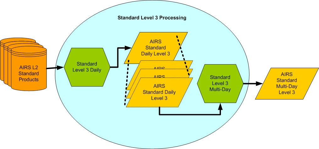
The fundamental resolution of the AIRS data products is defined by the fields of view of the instruments going into the products, as shown in Table 2. The output of Level 1B, Level 2 and Level 3 processing is organized into data products available as computer-readable files. The Level 1B and Level 2 data sets are organized into 240 daily granules, and Level 3 into daily and monthly products as separate ascending node, descending node and combined node. (For AIRS-team retrievals, Level 3 products prior to Version 7 included 8-day averages, or half the orbit repeat cycle.).
The flow of data through the processing software is represented schematically in Figure 13, Figure 14a, Figure 14b and Figure 15. Note that ammonia, carbon dioxide, and cloud phase and effective radius (see Table 2) are created by post-processing of the output of the basic Level 2 AIRS-team retrieval algorithm. Level 1C is produced from Level 1B, but is not currently used in producing the Level 2 products.

Figure 13: Level 1B processing steps. The product names in Level 1B quantities (AIRSBRAD, etc.) are discussed below.


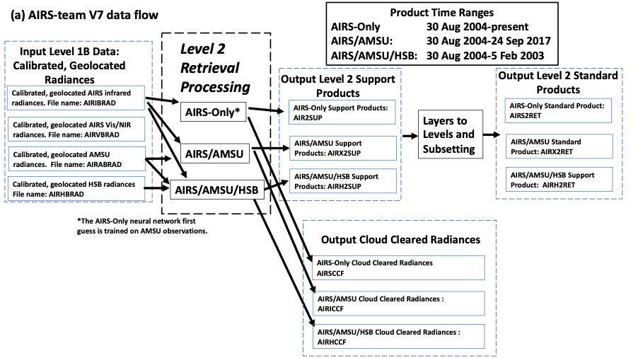
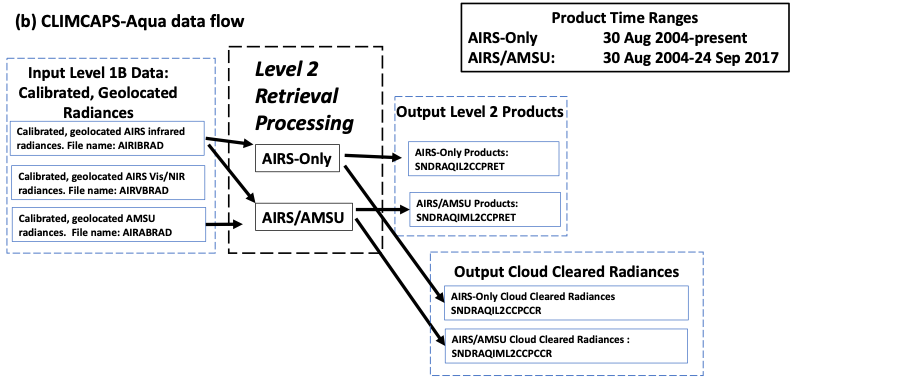
Figure 14: Data flow for the creation of Level 2 products from AIRS Level 1 input data, for the two retrieval systems, (a) AIRS-team V7, and (b) CLIMCAPS-Aqua. Products created by Level 2 retrieval processing are within the rectangular boxes, with blue dashed boxes surrounding similar products from different processing algorithms. Cloud cleared radiances are in separate files from other Level 2 retrieval products. For AIRS-team V7, all quantities in Table 2 are included in the three Level 2 processing types of AIRS-Only, AIRS/AMSU, and AIRS/AMSU/HSB. The product names in Level 2 quantities (AIRS2SUP, etc.) are discussed below in the ‘Short Names’ section. CLIMCAPS-Aqua retrieval products do not include HSB and are not separated into standard and support products.

Figure 15: High Level Flow Diagram of AIRS Standard Level 3 Processing.
AIRS/AMSU/HSB, AIRS/AMSU, and AIRS-only Level 2 and Level 3 Processing System
For both CLIMCAPS and AIRS-team retrievals, Level 2 and Level 3 data are generated by three different processing systems, depending on the combination of AIRS, AMSU and HSB (only for the AIRS-team retrieval) radiances input to the retrieval process, as illustrated in Figure 14a and Figure 14b. The three different types of Level 2 and Level 3 data are:
- AIRS-team AIRS/AMSU/HSB: This is the shortest time series of the three, starting on 30 August 2002 and ending five months later on 5 February 2003 when the HSB instrument stopped working.
- AIRS-team and CLIMCAPS AIRS/AMSU: This record is based on combined AIRS and AMSU observations and covers the period 30 August 2002 to 24 September 2016 (about 14 years), when AMSU-A2 failed.
- AIRS-team and CLIMCAPS AIRS-Only: This is the main product of the Version 7 retrieval system, first developed for Version 6 processing in anticipation of the loss of some or all AMSU channels. It does not use any microwave data and covers the entire duration of the mission.
Short Names
AIRS data products have a Short Name descriptor that can be used in data searches. Appendix A has details about file naming and a complete list of products. Tables 5, 6, 7, and 8 give the products, their Short Names, and the typical size of individual granules.
Level 1B products are provided from the infrared, visible/near-infrared, and the two microwave instruments. Since the infrared and visible/near-infrared products are large, Quality Assurance (QA) subset products are provided in a separate file to allow users to prescreen and decide which granules they want.
Products of the AIRS-team retrieval are divided into standard and support products. The standard products of Level 2 and 3 are intended for most users. The support product files are much larger and contain additional variables that are too large for the standard files or have not been rigorously validated. Since the cloud cleared radiances are large in data volume and many users are expected to have little interest in them, they are provided in separate output files, for both CLIMCAPS and AIRS-team retrievals.
For CLIMCAPS-Aqua Level 3 products, quality control can be either “Specific” (QCS) or “Comprehensive” (QCC). QCS products maximize yield of each individual species and level by collecting all cases where the corresponding *_qc value is 0 (best) or 1 (good). QCC products ensure analyses will be consistent across levels and species by including all cases where the whole profile is considered to be quality 0 or 1 (See the NASA CLIMCAPS L3 Format Definition V2).
Table 5: AIRS, AMSU and HSB Level 1B products, Short Names, and granule sizes.
|
Radiance Data Set |
Short Name |
Granule Size |
|
AMSU‑A radiances |
AIRABRAD |
0.5 MB |
|
HSB radiances |
AIRHBRAD |
1.7 MB |
|
AIRS radiances |
AIRIBRAD |
56 MB |
|
Vis/NIR radiances |
AIRVBRAD |
21 MB |
|
AIRS Level 1B QA |
AIRIBQAP |
5.6 MB |
|
Vis/NIR Level 1B QA |
AIRVBQAP |
1.1 MB |
|
AIRS Level 1C radiances |
AIRICRAD |
110 MB |
Table 6: AIRS-suite Level 2 products, Short Names, and granule sizes.
|
Level 2 Data Set |
Short Name, |
Short Name, |
Short Name, |
Granule |
|
AIRS-team Cloud‑cleared |
AIRH2CCF |
AIRI2CCF |
AIRS2CCF |
14 MB |
|
AIRS-team Standard |
AIRH2RET |
AIRX2RET |
AIRSRET |
3.5 MB |
|
AIRS-team Support |
AIRH2SUP |
AIRX2SUP |
AIRS2SUP |
25 MB |
|
CLIMCAPS Cloud-cleared radiances |
N/A |
SNDRAQIML2CCPCCR |
SNDRAQIL2CCPCCR |
~20 MB |
|
CLIMCAPS Product |
N/A |
SNDRAQIML2CCPRET |
SNDRAQIL2CCPRET |
~20 MB |
Table 7: AIRS-team Level 3 products, Short Names, and file sizes.
|
Level 3 Data Set |
Short Name, AIRS/AMSU/HSB |
Short Name, AIRS/AMSU |
Short Name, AIRS-Only |
File Size |
|
Daily standard product |
AIRS3STD |
AIRX3STD |
AIRH3STD |
~190 MB |
|
Monthly standard product |
AIRS3STM |
AIRX3STM |
AIRH3STM |
~200 MB |
|
Daily support product |
AIRS3SPD |
AIRX3SPD |
AIRH3SPD |
~245 MB |
|
Monthly support product |
AIRS3SPM |
AIRX3SPM |
AIRH3SPM |
~260 MB |
Table 8: CLIMCAPS-Aqua Level 3 products, Short Names, and file sizes.
|
CLIMCAPS-Aqua Level 3 Data Set |
Short Name, AIRS/AMSU |
Short Name, AIRS-Only |
File Size |
|
Daily product - Specific QC |
SNDRAQIML3SDCCP |
SNDRAQIL3SDCCP |
~230 MB |
|
Monthly product - Specific QC |
SNDRAQIML3SMCCP |
SNDRAQIL3SMCCP |
~240 MB |
|
Daily product - Comprehensive QC |
SNDRAQIML3CDCCP |
SNDRAQIL3CDCCP |
~230 MB |
|
Monthly product - Comprehensive QC |
SNDRAQIML3CMCCP |
SNDRAQIL3CMCCP |
~240 MB |
Versions
As of August 2021:
Level 1B data processing is Version 5.
Level 1C data is released under Version 6.7.
CLIMCAPS Levels 2 and 3 products, Version 2 is the most current.
AIRS-team retrieval Levels 2 and 3 products, Version 7 is the most current. For this version, significant improvements and modifications have been applied to the AIRS retrieval algorithm, especially the IR-only. A summary of noteworthy changes from Version 6 to Version 7 is provided in the document AIRS V7 Changes from V6. A more detailed characterization of the differences between Version 6 and Version 7 of various AIRS core data products can be found in the AIRS V7 L2 Performance Testing and Validation Report. Highlights of Version 7 include:
- Removal of bias in water vapor products
- Algorithm improvements leading to improved temperature, water vapor and ozone products
- Improved Stochastic Cloud Clearing Neural Network first guess
- Removal of ambiguity in surface classification
Data Access
AIRS products are available to the user community via the Goddard Earth Sciences Data and Information Services Center (GES DISC). Level 1 and AIRS-team retrieval Level 2 and 3 data files are provided in HDF-EOS2 format, which is based on the HDF4 version (https://hdfeos.org). Note that CLIMCAPS data files are provided in netCDF format.
The AIRS data products are available by searching on the GES DISC website.
Specific datasets can be found through various filters or keyword searches using, e.g., the Short Names given in this document, or by clicking on the links to dataset landing pages that are provided in the tables of data products in Appendix A.
The GES DISC provides additional information about obtaining AIRS data, data formats, and services such as data sub-setting tools. Contact information for further support from GES DISC can be found on the following website:
https://disc.gsfc.nasa.gov/information/documents?title=Contact%20Us