Summary of the guide, instruments, spectra, algorithm & data
About the AIRS Guide
The text in the AIRS Guide is intended to provide an overview of important aspects of the AIRS observing system, including instruments, data processing, and the data sets produced by this system. "AIRS" commonly refers to a suite of instruments on the Aqua spacecraft that includes the AIRS instrument and two microwave sounders (Advanced Microwaves Sounding Unit, or AMSU, and the Humidity Sounder for Brazil, or HSB). In addition to instruments, the AIRS mission includes several data processing algorithms, implemented as software in a data processing system.
The text covers radiance products produced by the calibration processing system as well as products of geophysical retrievals using the radiances. This includes both the AIRS-team retrieval algorithm Version 7 (V7) and the Community Long-Term Infrared Microwave Combined Atmospheric Product System (CLIMCAPS) retrieval algorithm and its products using radiances observed by the AIRS suite of instruments. CLIMCAPS is currently being used to retrieve records from the Cross-track Infrared Scanning (CrIS) instruments on the S-NPP and NOAA-20 spacecraft, in addition to the record from AIRS. CLIMCAPS is intended to provide a complete and consistent record from hyperspectral infrared instruments on three separate satellites, while the AIRS-team algorithm is applied to AIRS alone.
AIRS instrument and objectives
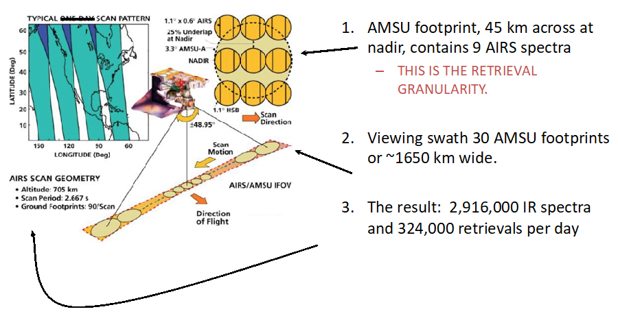
The Atmospheric Infrared Sounder (AIRS) instrument is a hyperspectral infrared spectrometer orbiting on the NASA Aqua spacecraft since May 2002. The primary goal of the AIRS mission is to provide detailed, global observations of the vertical structure of the Earth’s atmosphere. Its record of observations begins September 2002. The AIRS instrument, in conjunction with two microwave instruments, observes radiances emitted by Earth's surface and atmosphere, with observations covering most the Earth twice daily. AIRS spectra are resolved into over 2,000 channels, and as of this writing (July 2021) the AIRS instrument has obtained ~20 billion spectra.
Algorithms and data sets
The observed radiances are used in retrieval algorithms to infer atmospheric structure and other geophysical quantities (Chahine et al., 2006; Smith & Barnet, 2020). A variety of data products are publicly available from the systems that process AIRS instrument data. AIRS is one of several data sets produced by the NASA A-Train constellation of satellites (Parkinson, 2003).
The calibration processing system produces calibrated radiances observed along an orbit track (see Figure 2), referred to as Level 1B data. Radiance data are used by scientists directly to detect small changes in Earth's upwelling radiance features for climate trending, and used in geophysical retrievals of atmospheric temperature, water vapor and trace gases. They are also used for spectral and radiometric calibration of broadband instruments and comparison with other hyperspectral instruments.
Retrieved quantities are referred to as Level 2 data, and they are generated by both AIRS-team and CLIMCAPS-Aqua systems. AIRS-team V7 and CLIMCAPS-Aqua have a common heritage: CLIMCAPS shares a common history with the AIRS-team Version 5 but deviates substantially in its error quantification, uncertainty propagation, a-priori definition (e.g., MERRA2 reanalysis for temperature, water vapor and ozone), and diagnostic reporting (e.g., full averaging kernel matrices). AIRS-team V7 changed considerably since Version 5, including a neural network initial state. For these and many other reasons the two data records have structural differences despite a common heritage. Geophysical quantities reported on regular space-time grids are referred to as Level 3 data.
Timeline of data records
Development of the Science Team algorithms began prior to the launch of Aqua and these algorithms have been updated regularly. These updates are motived by improvements in algorithm performance, but also made necessary by the failure of HSB early in the mission and by degradation of some AMSU channels. As of early-2021, AIRS-team Level 2 processing is at Version 7; the first data release in 2003 was Version 3.
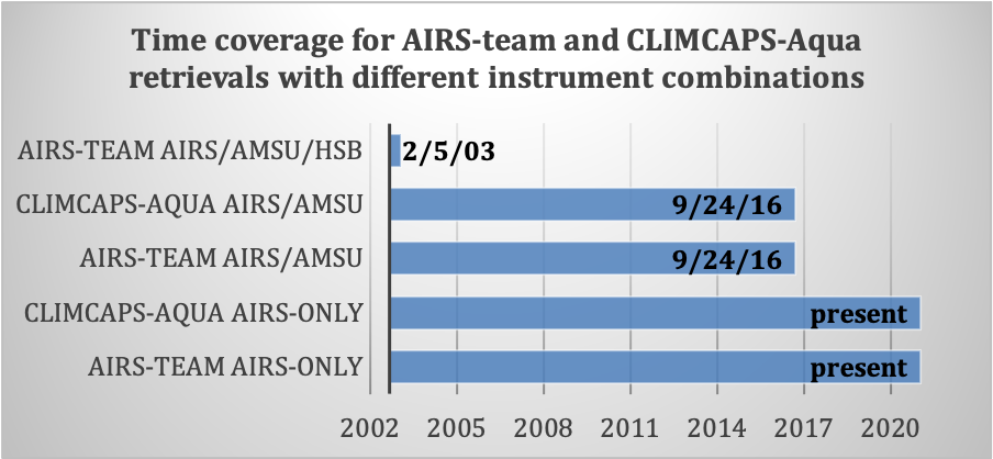
The AIRS-team retrieval system produces three distinct Level 2 data sets: a five month AIRS/AMSU/HSB record, a 14 year AIRS/AMSU record, and a complete AIRS-Only record. The CLIMCAPS system produces AIRS/AMSU and AIRS-only records, but no AIRS/AMSU/HSB record. The two records common to AIRS-team and CLIMCAPS have identical time coverage (see Figure 1 below).

Figure 1: Time coverage of retrievals from the AIRS-team and CLIMCAPS-Aqua systems using data from different combinations of the AIRS, AMSU, and HSB instruments.
Quality control and validation
Most algorithm development effort has gone into Level 2 because it is a large and complex system. Also, the resulting geophysical quantities (e. g., atmospheric temperature and water vapor) are fundamental to theoretical and model depictions of the atmosphere, and are thus often easier to interpret than are calibrated radiances. This interpretation is aided by a quality control information about retrieved quantities.
Many of the quantities from the AIRS-team retrieval have been extensively tested and validated against other observations. The CLIMCAPS system is just beginning to be applied to the AIRS radiances, so its characteristics are not yet as well documented as the AIRS-team record. One goal in the near future is a comparative study of the AIRS-team and CLIMCAPS data sets. Please note that this document describes only the algorithms and associated data sets. Their geophysical assessment is presented elsewhere (see the CLIMCAPS-Aqua V2 Performance Test Report).