Vertical Cross-Sections of CloudSat, CALIPSO, and AIRS Cloud Fields
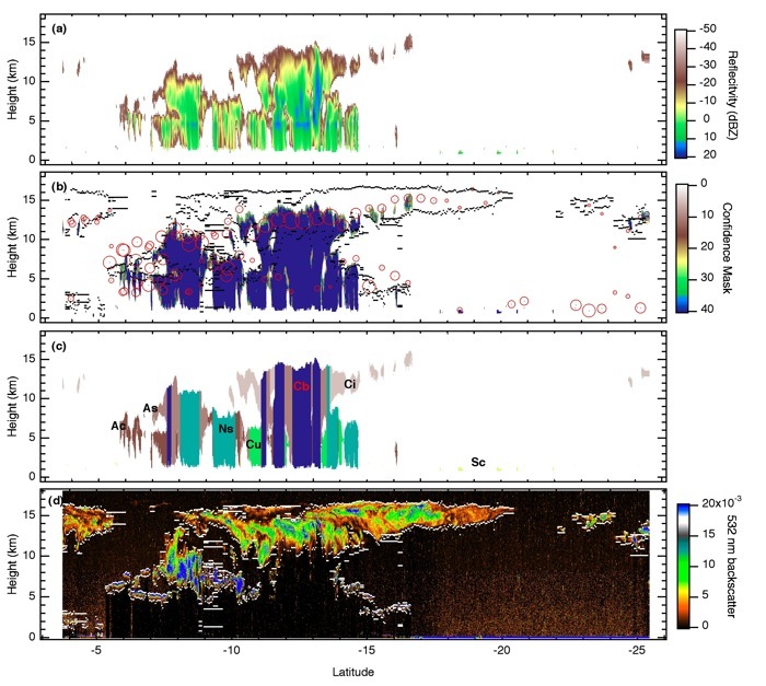
The cross-sections above are from a granule in the Tropical Indian Ocean and show collocated CloudSat, CALIPSO, and AIRS cloud fields as a function of height. The images illustrate the ability of AIRS to resolve quantitatively meaningful cloud information. (a) CloudSat94 GHz reflectivity from the 2B-GEOPROF product. (b) CloudSat cloud confidence mask from the 2B-GEOPROF product restricted to cloud confidence values > 20. The 5 km CALIPSO cloud feature mask cloud top heights and bases are shown in black. The centers of the red circles show the AIRS V5 (up to) two layers of cloud top height and associated values of cloud fraction (smallest to largest circles are from 0 to 1, respectively). Likely unphysical cloud layers with cloud fraction < 0.01 are not included. (c) CloudSat cloud classification from the 2B-CLDCLASS product. (d) CALIPSO 532 nm total attenuated backscatter (colorized) and 5 km cloud feature mask cloud top heights and bases shown in white.
Citation
Kahn, B. H., Chahine, M. T., Stephens, G. L., Mace, G. G., Marchand, R. T., Wang, Z., Barnet, C. D., Eldering, A., Holz, R. E., Kuehn, R. E., and Vane, D. G.: Cloud type comparisons of AIRS, CloudSat, and CALIPSO cloud height and amount, Atmos. Chem. Phys., 8, 1231-1248, 2008.
