-
The AIRS Browse Tool for Applications was created to display imagery created by the Atmospheric Infrared Sounder instrument aboard NASA’s Aqua satellite along with select imagery from other NASA missions. The tool pulls imagery archived in GIBS, NASA's Global Imagery Browse Services system. GIBS provides quick access to almost 200 NASA satellite image products covering every part of the world, and many products are available within 3-5 hours of observation.
Open the AIRS Browse Tool
-
A fully automated volcano plume detection rapid response system developed at NASA's Jet Propulsion Laboratory uses near real-time data from AIRS and triggers on threshold exceedances of sulfur dioxide (SO2). The system provides imagery of SO2, dust (a proxy for volcanic ash), clouds (which can mask the SO2 signal), and infrared.
Open the Volcano Tool
-
This app from NASA's EOSDIS provides the capability to interactively browse over 900 global, full-resolution satellite imagery layers and then download the underlying data. Many of the imagery layers are updated daily and are available within three hours of observation – essentially showing the entire Earth as it looks "right now".
To view AIRS layers in Worldview, open the tool, select "Add Layers", and type AIRS in the search field.
Open Worldview
-
Giovanni is a Web-based application developed by the Goddard Earth Sciences Data and Information Services Center (GES DISC) that provides a simple and intuitive way to visualize, analyze, and access vast amounts of Earth science remote sensing data without having to download the data. Giovanni is an acronym for the Geospatial Interactive Online Visualization ANd aNalysis Infrastructure. Giovanni utilizes AIRS global 1.0° x 1.0° Level-3 Products.
Open Giovanni
-
This portal combines satellite observations with weather forecast models and provides interactive visualization and online analysis tools. This work supports improved hurricane science and forecasting, and it's inspired by the needs of NOAA’s Hurricane Forecast Improvement Project (HFIP). AIRS data is featured on the tool. There is also a helpful tutorial video.
Visit the Portal
-
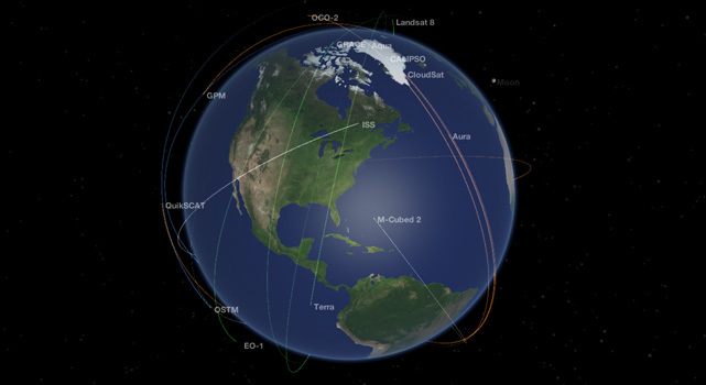
NASA's "Eyes on the Earth" application lets you monitor our planet's vital signs, visualizing data from various NASA Earth-observing missions, including AIRS. The location of all of NASA's operating Earth-observing missions can be displayed in real time. Get a sneak peek at upcoming missions and learn how NASA is planning to study our Earth in the future. With the “Latest Events” feature, you can explore geo-located satellite images of recent Earth events, including algal blooms, super storms and wildfires.
Visit Eyes on the Earth Page
View Data


