News | December 6, 2022
NASA's AIRS Instrument Tracks Volcanic Sulfur Dioxide Plume from Mauna Loa to Texas over Three Days
The Atmospheric Infrared Sounder (AIRS) instrument aboard NASA's Aqua satellite detected volcanic sulfur dioxide (SO₂) plumes emanating from Hawaii's Mauna Loa volcano, which started erupting late Sunday, Nov. 27, 2022, at 11:30 p.m. Hawaiian Standard Time (9:30 a.m. UTC, Nov. 28). The AIRS images and animation shown here were taken from seven overpasses, capturing the eastward propagation of SO₂ volcanic plumes from Mauna Loa, reaching Texas in three days following the strong subtropical jet stream.
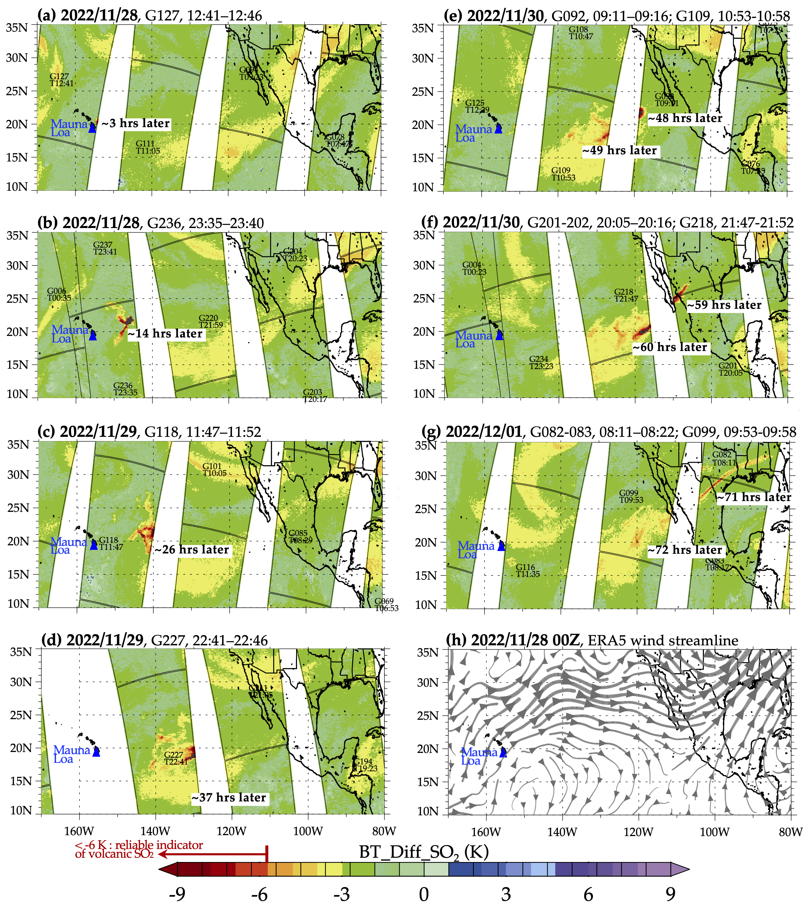
Starting from the upper left frame of the image (frame a) — captured at 2:41 a.m. HST (12:41 UTC) on Nov. 28, around three hours after the eruption began — a red patch that represents an SO₂ plume can be seen east of the volcano, which is shown as a blue triangle, then moving east and diffusing through subsequent frames. By 71 hours after the eruption (frame g), the eastern part of the plume is over the southeastern United States. The last frame (h) shows the wind field at 300 hPa on Nov. 28 (00:00 UTC), taken from the European Centre for Medium-Range Weather Forecasts Reanalysis product (ERA5), representing a typical circulation in the region with the upper tropospheric jet stream highlighted in bold arrows.
To better view the eastward movement of the SO₂ plume, an animation is shown below covering the same three day time period as the image above. The same AIRS brightness temperature data is used but the color scale is modified to emphasize the SO₂ plume and its eastward motion. The corresponding wind fields from ERA5 are also updated for each frame of the animation.
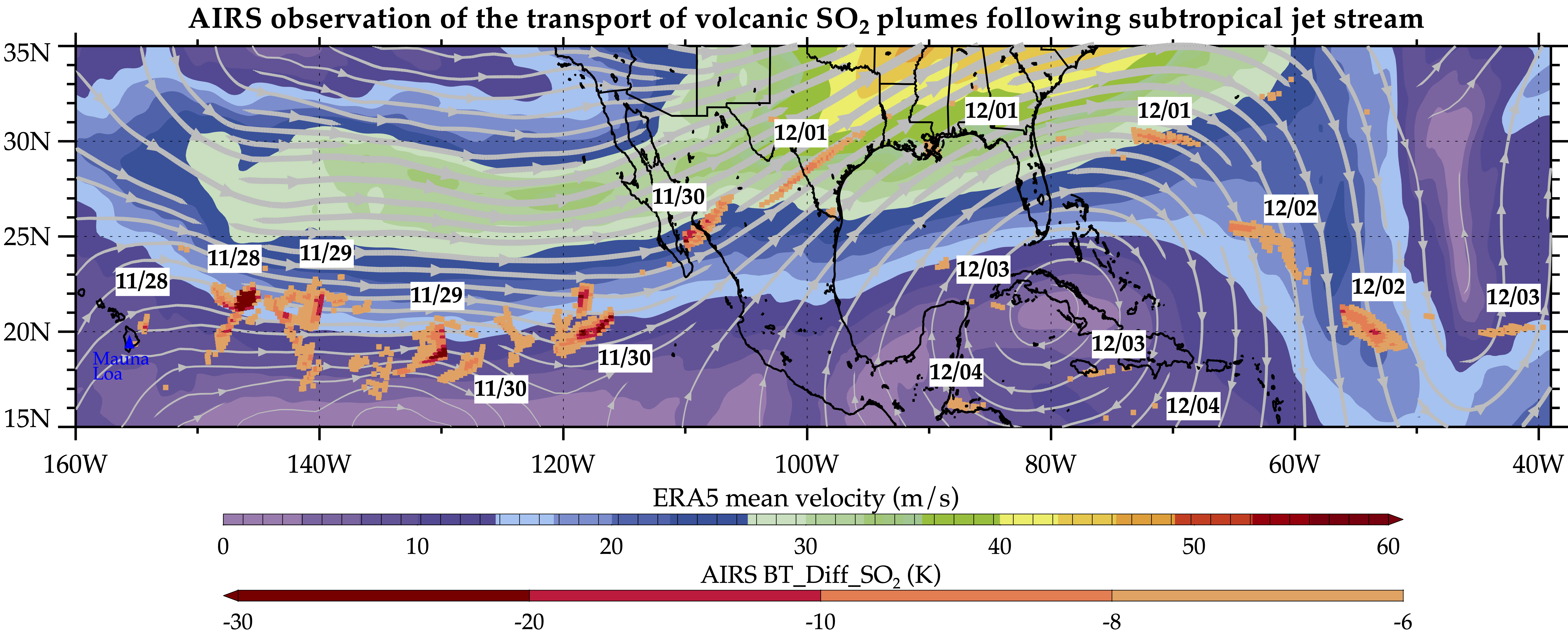
During this time of the year, the North America continent is experiencing a subtropical jet stream, which is a narrow band of strong wind in the upper troposphere blowing from west to east, caused by temperature differences between colder air at mid-latitudes and warmer air from the equator. The jet streams transport not just weather systems that affect us, but also the volcanic SO2 plumes from this eruption in Mauna Loa. Below is another figure showing a one-week composite of volcanic SO2 plumes observed by AIRS (orange-red color bar) since the Mauna Loa eruption on Nov. 28, overlaid with mean wind speeds (purple-red color bar) and streamlines from ERA5. This further demonstrates that the volcanic SO2 plumes being transported follow the subtropical jet stream, and parts of the plumes are further diluted within the anticyclone (high pressure system in the ridge of the jet stream) since Dec. 3.
SO₂ can be harmful to the human respiratory system when inhaled. In the atmosphere, it can also lead to the formation of other gaseous sulfur oxides (SOₓ). These substances can react with other chemicals to form particulate-matter pollution, which can cause breathing problems, contribute to acid rain, and reduce sky visibility.
AIRS measures the amount of radiation reaching the instrument from the top of the atmosphere at more than 2,000 different wavelengths. Brightness temperature (BT) is a measure of the amount of radiation, and the images and animation show the difference between BT observed at two different wavelengths. One of the wavelengths (wavenumber 1361.44 cm-1 or 7.3 µm) is sensitive to atmospheric SO₂, and the other (wavenumber 1433.06 cm-1 or 7.0 µm) is not, so the difference between the two measurements can give a reliable signal of volcanic SO₂ plumes.
A fully automated volcanic plume detection rapid response system that uses AIRS data has been developed at the Jet Propulsion Laboratory in Southern California. This tool is available at the AIRS Rapid Response website, where detections of the most recent volcanic SO₂, dust, and clouds, in visible and infrared images, are updated in near real-time when a volcanic event anywhere on Earth triggers the system. AIRS historical detections of volcanic SO₂ and dust are archived on the site at https://airs.jpl.nasa.gov/volcanic_plumes/.
AIRS, in conjunction with the Advanced Microwave Sounding Unit (AMSU), senses emitted infrared and microwave radiation from Earth to provide a three-dimensional look at the planet's weather and climate. Working in tandem, the two instruments make simultaneous observations down to Earth's surface. With more than 2,000 channels sensing different regions of the atmosphere, the system creates a global map of atmospheric temperature and humidity, cloud amounts and heights, greenhouse gas concentrations, and many other atmospheric phenomena. Launched into Earth orbit in 2002 aboard NASA's Aqua spacecraft, the AIRS and AMSU instruments are managed by JPL, under contract to NASA. JPL is a division of Caltech.
More information about AIRS can be found at https://airs.jpl.nasa.gov.
Image and animation credit: Tao Wang, NASA/JPL-Caltech.


