News | September 1, 2005
The Best Views on Climate: Chahine's Vision Lives On Through AIRS
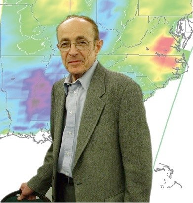
AIRS Team Leader and more, Moustafa T. Chahine
In a career spanning five decades, Moustafa Chahine's work in the field of atmospheric science has helped forward our understanding of Earth's atmosphere and its processes. From studying the clouds of Venus to spearheading the successful Atmospheric Infrared Sounder, Chahine continues to guide discovery and search for answers to some of the most difficult questions in climate science.
It was 1957, the era of Sputnik, and Moustafa Chahine, or "Mous" as he came to be known by his colleagues while working on his Ph.D. at U.C. Berkeley, saw a picture of JPL Director William Pickering, Wernher von Braun, and Iowa professor Jim Van Allen, standing shoulder-to-shoulder triumphantly holding over their heads a model of the Explorer 1 satellite they had just launched into space. "It was fantastic," Chahine recalls, and the moment crystallized his own decision to work in the space program.
From fluid flow to remote sensing
Invited to work at JPL in 1960, Chahine began his career studying shockwaves to attack problems associated with the reentry of a space capsule to Earth. But with the Lab redirecting much of its resources to the ambitious Voyager project, Chahine was faced with the decision to either leave and continue his research elsewhere or stay and change his field of interest. Chahine stayed, and chose to re-focus his efforts on a challenge that shared a common component that dovetailed with his previous research. That common component was Earth's atmosphere, and the challenge involved the interpretation of radiation, or lightwaves at many wavelengths, emitted from an atmosphere as measured by a satellite. This exploration would lead him to develop a method for retrieving temperature profiles to study Earth and other planets. His first application was to study the cloudy atmosphere of Venus. In the meantime, the science of weather prediction was evolving, and an intersection between Chahine's work and the work being done to create global data sets of Earth's atmosphere would become inevitable.
A history of weather forecasting
The motivation for temperature sounding from space came from the development of numerical weather prediction during the 1950s. MIT meteorology professor Jule Charney,who in the mid-1950s first demonstrated that a computer could predict the weather, believed the only information needed was accurate vertical temperature profiles of the atmosphere. The forecast model could then use the information in the profiles to infer wind velocity and predict the movement of fronts. Charney, however, had a problem. There wasn't enough data to feed a global model. Temperature profiles were routinely gathered by the Weather Bureau from balloons but only over land, and lots of interesting weather happened over the oceans. To compound the problem, only the relatively wealthy Northern Hemisphere countries operated balloon networks and shared the data.
Charney's connections to one of the great figures in 20th century meteorology, the U.S. Weather Bureau's Dr. Harry Wexler, offered the solution to his problem. One of the first goals for NASA leaders when the agency started operations in late 1958 was to prove the utility of space technology,and improving weather forecasting was obviously a useful thing to try to do. So NASA arranged with Wexler's Weather Bureau to develop weather satellites. The new Goddard Space Flight Center in Maryland became home base for the effort, which initially focused on imagery satellites based on an Army reconnaissance satellite design.
The idea for generating temperature profiles from satellites came from another U.S. Weather Bureau alumnus, Lewis D. Kaplan, who in 1959 proposed that one could infer atmospheric temperature from the energy emitted by carbon dioxide molecules in the atmosphere. With this latest advancement, Charney could now finally envision a way to get the global data he needed. After arriving at JPL by way of MIT, Kaplan influenced Chahine's decision to apply his fluid flow analytical skills to the equations necessary to transform satellite infrared data into atmospheric temperature profiles. Chahine, who had spent much of the 1970s building JPL's oceanography program and working to get funds to build his atmospheric temperature sounder idea, thought the next-generation sensor should have a vertical resolution of 1 kilometer, and an accuracy of 1 degree Celsius.
The National Climate Program Act of 1978 succeeded in getting the planning for climate research started, including the development of an observing system to support the research. This effort went nowhere quickly, however. On paper, the observing system was massively expanded to become part of the "Space Station Freedom" project with a set of giant, astronaut-tended polar platforms that were supposed to provide every kind of Earth observation possible.
Chahine's instrument proposal, the Atmospheric Infrared Sounder (AIRS), received its earliest funding as part of this concept. Chahine and AIRS had a number of advantages over other investigators. One was that as a weather prediction instrument, AIRS had strong support even from people who weren't interested in climate, and the Department of Defense was interested in its infrared detector technology. Additionally, AIRS contributed directly to climate studies. Most climate models showed that as greenhouse gases increased, the atmosphere would get warmer and wetter. There would also be a pattern to the warming: the upper troposphere would warm more than the lower troposphere,the stratosphere would actually cool, and the boundary between the troposphere and the stratosphere (the tropopause), would move.
The older National Oceanic and Atmospheric Administration temperature sounders didn't have the resolution to see these changes, but AIRS could, if its measurements were maintained long enough. So AIRS stayed alive. Initially, it was scheduled for two platforms, in morning and afternoon orbits, but finally wound up on only one, the satellite formerly known as EOS-PM, now called Aqua.
The AIRS achievement
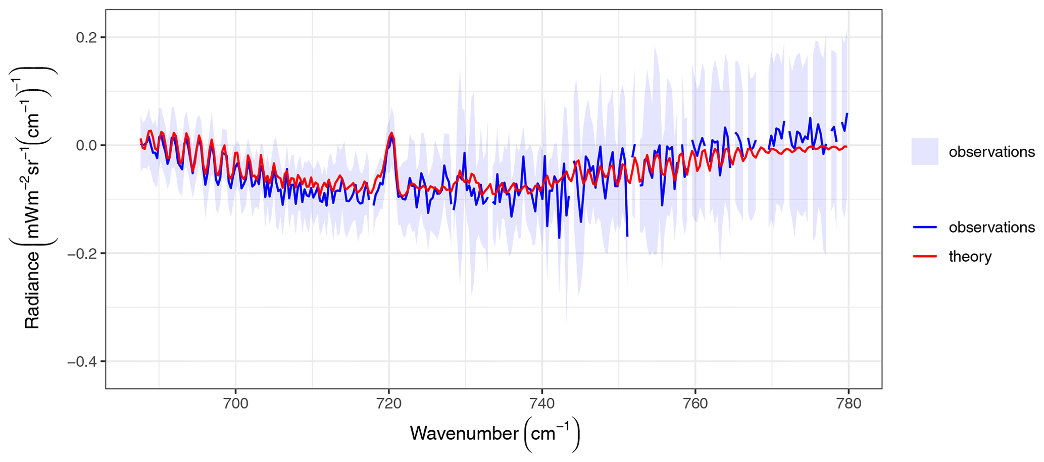
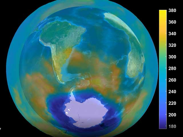
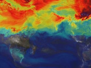
Since its launch aboard Aqua in 2002 from Vandenberg Air Force Base, AIRS has operated like a champ, maintaining flawless operations with superb calibration accuracy and stability. Its global data sets are being distributed to numerical weather prediction centers around the world, and AIRS has provided the first-ever global maps of water vapor in the upper troposphere. AIRS is also providing new maps of global carbon dioxide in its highest resolution yet, and the first-ever global map of carbon dioxide is in the works.
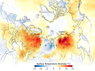
Beyond the goal of improving weather forecasting, AIRS was also the first instrument ever designed with the sensitivity requirements to study climate change. AIRS water vapor measurements in the upper troposphere have proven to be accurate enough to make it possible to determine if the average amount is increasing or decreasing, which would answer one of the important questions about global warming. Other theorized consequences of global warming such as a speed-up of the cycling of water through the atmosphere by evaporation, cloud formation and precipitation and an increase in the frequency and intensity of severe storms (such as Hurricane Katrina) can also now be tested with the global and continuous coverage that AIRS provides.
For most climate investigations the 'signal' is so small and the change so gradual that many years of observations must be accumulated. But AIRS is so accurate that the steady increase in atmospheric carbon dioxide, one of the primary greenhouse gases, is clearly discernible even with just a couple of years of data from its 2002 launch.
The future
Since the ability to study climate change requires a long period of top-quality observations, it is very important to continue the task that the AIRS project has started, even after the AIRS instrument system eventually reaches the end of its mission life span. NASA and its sister organizations recognize the importance of such data continuity, and a series of satellites has been planned to provide that continuity. In perhaps a decade, a new series of weather satellites called the National Polar-orbiting Operational Environmental Satellite System (NPOESS) will be launched. It is hoped that the accuracy and quality of the observations from these satellites will also meet the requirements for climate studies. In the meantime, there is also the NPOESS Preparatory Project, a satellite intended to bridge the expected gap between the end of the Aqua satellite mission which includes AIRS and the launch of the first NPOESS satellite. Many of the AIRS scientists are also members of the NPOESS and Preparatory Project science teams, and will bring their expertise to ensuing programs that will carry weather and climate studies into the future.
Almost 30 years have passed since Chahine's first idea of creating an instrument to provide a high-resolution data set of Earth's atmosphere. Along the way, Chahine founded JPL's Science Division, spent 15 years as the Lab's Chief Scientist and worked with the World Climate Research Programme to establish a program to study the Earth's global energy and water cycle. But he never stopped guiding the idea of AIRS into reality,and AIRS management, science, engineering and support personnel have all participated in making the AIRS mission a successful one.
After so many successes to date, what is the brightest? Perhaps the biggest validation comes from AIRS' latest achievement: the Joint Center for Satellite Data Assimilation has shown that by using just one tenth of a percent of the AIRS data, the forecasts improved in one fell swoop by as much as it would normally take several years of steady computer work to achieve. The JCSDA is now planning to use much more of the AIRS data, which they expect to result in yet another leap forward in forecast improvement. The challenges were many, and the twists and turns were precarious. Was it worth it? With the work currently underway by the AIRS team at JPL and elsewhere, Chahine says, "Wait, this is just the beginning!" Chahine's vision lives through AIRS.
---
Written by Sharon Ray, AIRS Outreach Coordinator and Erik Conway, JPL Historian, September 2005
[[IMAGE||/system/internal_resources/details/original/120_droppedImage_22.jpg||Left||701||droppedImage_22||AIRS Team members at the Jet Propulsion Laboratory||||381||]]