News | May 18, 2006
China Dust Storm of April 2006
Image Credit: Sung-Yung Lee, Jet Propulsion Laboratory and Sergio DeSouza-Machado, University of Maryland Baltimore County||||290||http://photojournal.jpl.nasa.gov/archive/PIA11009.mov]]
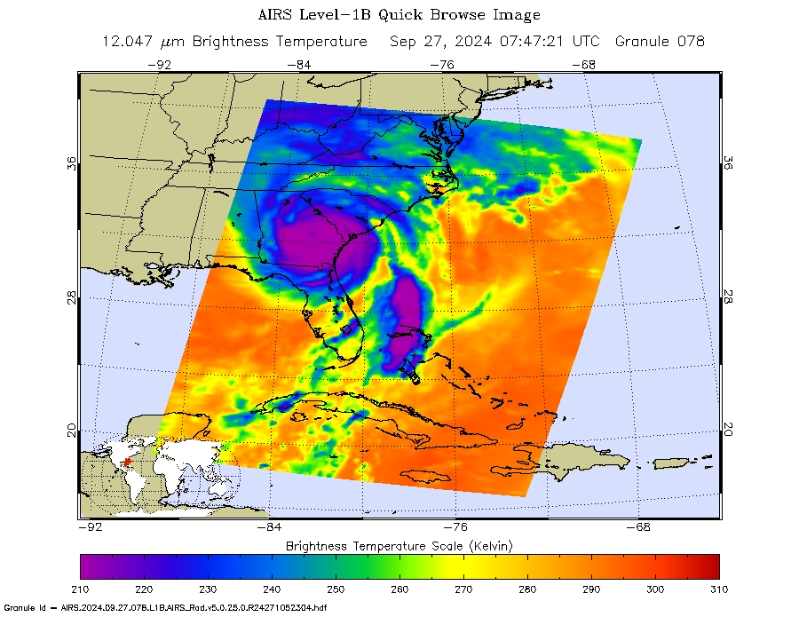
Large dust storms emanating from northwestern China's Inner Mongolia region traveled eastward and caused the worst period of air pollution in six years in Beijing. As winds carried the storm along, other regions were also affected. An animation created from data taken by the Atmospheric Infrared Sounder (AIRS) shows how the dust from these storms travels around the globe.
This animation, created by AIRS researcher Sung-Yung Lee, is made from a series of images created with data from the AIRS instrument. The animation spans 10 days beginning on April 7, 2006 and ending on April 16. The magenta color in the images represents where AIRS detects dust in the atmosphere. The images are preliminary as scientists work on verifying the accuracy of the AIRS ability to detect dust, and an effort to cross-compare the AIRS results with what other sensors see is just getting under way.However, the spatial consistency and temporal evolution we see in the AIRS data look plausible, even over land.
The animation begins on Saturday April 7, a large dust cloud originating from China's inner Mongolia region is detected by AIRS, and it begins to travel east. The images show that while the large cloud moves away, smaller dust clouds continue to be created in the region.
Stepping through the animation you'll notice on April 10 the large cloud seems to disappear, only to re-appear on the 11th. This is likely due to the presence of clouds such as altocumulus, altostratus or cirrus, which lie at higher altitudes and so block the clouds, which block the ability of AIRS to detect dust. Also, cirrus clouds are thin wispy clouds which can look similar to dust in the infrared and therefore make it difficult for the AIRS system to detect the dust. However, sometimes the effect of the clouds disappearing can also be due to a data gap, known as a "gore". As AIRS scans the atmosphere in its polar orbit around Earth it covers most of the globe, but it can't cover 100% the globe in one day. This is because the AIRS swaths (the path covered by the instrument as it travels over Earth) don't butt up against each other perfectly in some areas, especially near the equator (Think of wrapping a ribbon around a ball from north pole to south pole, trying to cover the entire ball.You'll have lots of overlap at the poles, but some gaps at the equator).
As the animation progresses, the dust cloud continues to travel from west to east and moves across the Pacific Ocean. By Friday the 14th it has traveled far enough eastward around the globe to reach the west coast of the United States, and by the 16th another large dust cloud has taken form and can be seen off the coast of China.
What is also interesting is what the images created from the 13th through the 16th may also reveal. The AIRS dust flag gets triggered over the eastern US and shows a cloud moving into the Atlantic Ocean.This could be dust from Asian storms that have traveled around Earth and have reached as far as the Atlantic. However, the detection of dust by AIRS over the eastern US has not been verified at this time to be from the Asian storms.
About the AIRS Dust Flag
How does an infrared instrument detect dust? The AIRS instrument expects the atmosphere to have a typical "spectral signature"- a plot of the reflected and absorbed electromagnetic radiation at different wavelengths. If this signature is skewed in a particular way, it is likely due to the detection of dust. The skewness is also affected by the surface (sea or land or vegetation) underneath the dust. To deduce dust from the data is rather complicated, and the AIRS dust flag has been tested mostly over ocean and found to be very effective (the AIRS dust flag was originally developed for ocean scenes). But as of this writing, the effectiveness of the flag over land has not been evaluated.
A Bit More Technical
According to Sergio DeSouza-Machado, who created the dust flag for the AIRS data, the peak absorption of sandstorm dust in the infrared is at about 1000 cm-1, and drops off rapidly on either side. This means that sand lifted into the air and blowing over ocean would lower the measurements at 1000 cm-1, compared to measurements at 820, 1231 cm-1 and other similar channels. By choosing a set of representative channels and scoring brightness temperature differences between pairs of channels in the set, AIRS can detect the presence of dust in the atmosphere day or night.
Background about the China Dust Storm
A Siberian cold front caused large dust storms to be created in northwestern China's Inner Mongolia region and Gansu province. As these storms hovered over northern China, they ushered in the worst period of air pollution in six years. Air quality in the capital city of Beijing reached hazardous levels, and elderly people and children were warned to stay indoors. At this latitude on the globe the air moves from west to east, so the dust storm which originated in China will move towards Japan. However, the storm is expected to weaken as it enters the Bohai Sea and the East China Sea. South Korea, which also lies in the storm's path, was also greatly affected, and the storm was its second-worst this year. The dust is actually a combination of sand from the Gobi Desert and chemicals from Chinese industrial cities that blow to the Korean Peninsula from westerly winds in April and May, reducing visibility and filling the country's skies with a thick blanket.
The storms are caused by soil erosion, desertification and overgrazing in grasslands - deforestation and expanding deserts in inland China are believed to be the cause, and these types of storms appear to be worsening. Coupled with with prolonged hot, dry weather in inland China the past couple of years, this year's dust storms have been more frequent, and the storms are moving faster as desert areas become extended.
The animation created from data taken by the Atmospheric Infrared Sounder (AIRS) shows how the dust from these storms travel around the globe. Large dust storms are not only a health concern, but they can affect atmospheric chemistry and rainfall patterns, and transport micro-nutrients and micro-organisms. The deposited dust can kill coral, fertilize ocean photo-plankton, or melt ice as dust makes that surface absorb rather than reflect sunlight. Dust storms are now more frequent, in part because of climatic variability and in part because of land use change such as deforestation or overgrazing. [Jickells, T., et al. (2005)]
-----
Written by: Sharon Ray, Jet Propulsion Laboratory
Science content provided by:
Sung-Yung Lee, Jet Propulsion Laboratory
Sergio DeSouza-Machado, University of Maryland Baltimore County
Eric Fetzer, Jet Propulsion Laboratory
Bjorn Lambrigtsen, Jet Propulsion Laboratory
Papers:
S. G. DeSouza-Machado, L. L. Strow, S. E. Hannon, and H. E. Motteler, Infrared dust spectral signatures from AIRS, GEOPHYSICAL RESEARCH LETTERS, VOL. 33, L03801, doi:10.1029/2005GL024364, 2006
Jickells, T., et al. (2005), Global iron connections between desert dust, ocean biogeochemistry and climate, Science, 308, 67 71.
 Sung-Yung Lee
 Sergio DeSouza-Machado