News | October 6, 2011
Your paper, three questions: Temperature and water vapor variance scaling in global models: Comparisons to satellite and aircraft data

Brian Kahn. Credit: Sharon Ray
Climate models are doing a decent job of capturing spatial differences over the globe for both temperature and water vapor, but does this hold true at small scales?
We are beginning to think about the increasing importance of making satellite observations at much smaller spatial scales.
What is your paper about?
Our paper is about the similarities and differences of temperature and water vapor "spatial variability" between a few well-known climate models, in situ aircraft, and Atmospheric Infrared Sounder (AIRS) satellite data. You can imagine that in a given climate model, the entire global atmosphere is divided into boxes in all three spatial dimensions. Climate modelers are concerned about how to deal with the variability of temperature and water vapor within every single climate model grid box. This variability is important for many reasons, which includes the formation of clouds and precipitation, two very important properties for understanding the future evolution of Earth's climate. Either you have to treat these quantities as a single number within every grid box, which they are not, or represent the distributions in some methodological way that we call a "parameterization". These results will help shape future climate model development in a way that will represent the variability in a more realistic way.
What did your research reveal?
The main results of the paper showed that the global climate models do not have enough of this "spatial variability" of temperature and water vapor at the small scales, suggesting a serious limitation in their behavior. To their benefit, the models seem to get some of the important differences that exist between temperature and water vapor, which is quite important. Overall, they also seem to capture the spatial differences between the tropics, mid-latitudes, and high latitudes, and also differences through the depth of the troposphere, the lowest layer of Earth's atmosphere. However, the differences with the satellite and aircraft data are substantial and are expected to have important impacts on cloud and precipitation processes. If these processes in the climate models are problematic, we expect that calculations of future changes in clouds and precipitation will also be problematic.
What part of your research do you consider to be the most significant?
The aircraft measurements were taken in a region of low-level cloud cover near the coast of South America a few years ago, and are compared to the AIRS data. They showed that the variability "decreases more quickly" at spatial scales smaller than 20-30 kilometers or so. Therefore, the AIRS satellite observations, which can only observe this variability at scales of 50 kilometers or more, cannot observe this important aspect of the variability at tiny scales. As a result, we are beginning to think about the increasing importance of making satellite observations at much smaller spatial scales (higher spatial resolution).
Abstract: "Temperature and water vapor variance scaling in global models: Comparisons to satellite and aircraft data"
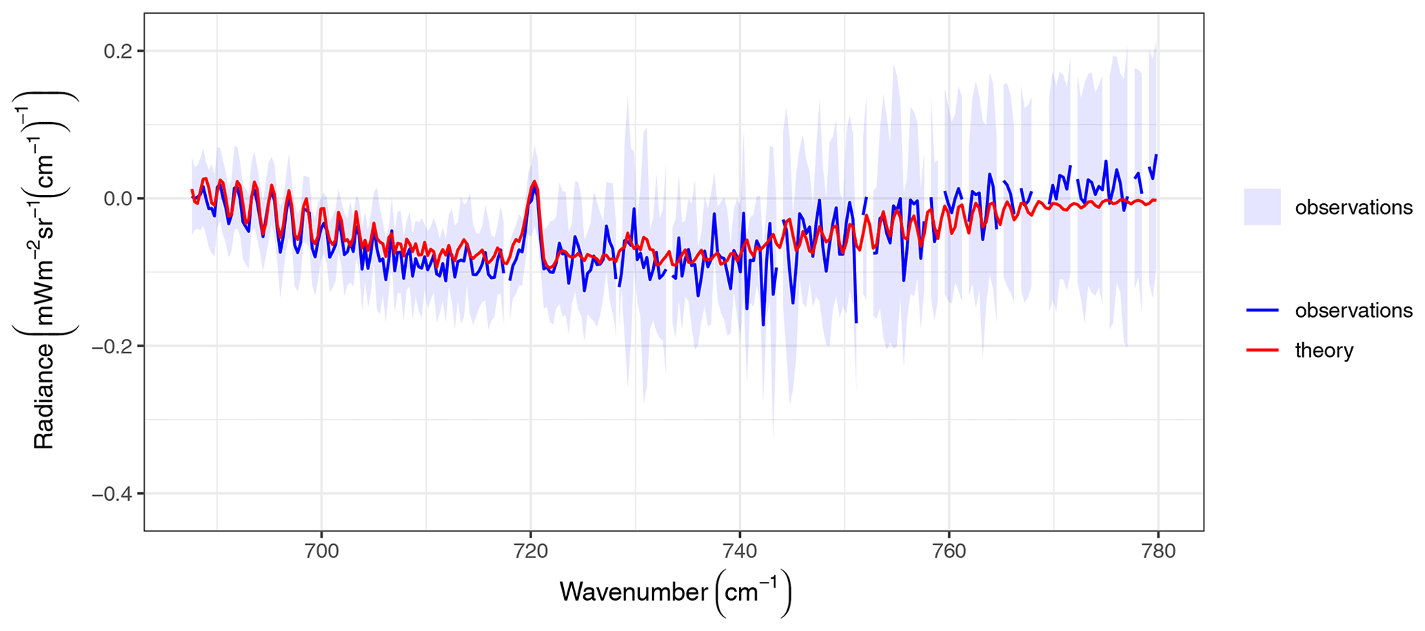
Observations of the scale dependence of height-resolved temperature T and water vapor q variability are valuable for improved subgrid-scale climate model parameterizations and model evaluation. Variance spectral benchmarks for T and q obtained from the Atmospheric Infrared Sounder (AIRS) are compared to those generated by state-of-the-art numerical weather prediction "analyses" and "free-running" climate model simulations with spatial resolution comparable to AIRS. The T and q spectra from both types of models are generally too steep, with small-scale variance up to several factors smaller than AIRS. However, the two model analyses more closely resemble AIRS than the two free-running model simulations. Scaling exponents obtained for AIRS column water vapor (CWV) and height-resolved layers of q are also compared to the superparameterized Community Atmospheric Model (SP-CAM), highlighting large differences in the magnitude of CWV variance and the relative flatness of height-resolved q scaling in SP-CAM. Height-resolved q spectra obtained from aircraft observations during the Variability of the American Monsoon Systems Ocean-Cloud-Atmosphere-Land Study Regional Experiment (VOCALS-REx) demonstrate changes in scaling exponents that depend on the observations' proximity to the base of the subsidence inversion with scale breaks that occur at approximately the dominant cloud scale (~10-30 km). This suggests that finer spatial resolution requirements must be considered for future satellite observations of T and q than those currently planned for infrared and microwave satellite sounders.