News | April 19, 2010
AIRS captures ash, ice and sulfur dioxide in Iceland's Eyjafjallajokull volcanic cloud
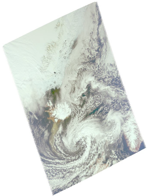
Image from AIRS visible light sensor.
April 15, 2010
[[IMAGE||/system/internal_resources/details/original/75_screenshot_01.jpg||Left||460||screenshot_01||The infrared sensor on the AIRS instrument can distinguish between particles of ash and ice contained in the volcanic cloud. Image Credit: Fred Prata, Norwegian Institute for Air Research||||383||]]For the second time this month, Iceland's Eyjafjallajokull volcano (pronounced "Aya-fyatla-jo-kutl") erupted. The latest eruption, on Wednesday, April 14, spewed a cloud of ash into the atmosphere and is disrupting air travel in Northern Europe and around the world.
The Atmospheric Infrared Sounder (AIRS) instrument on NASA's Aqua satellite flew over the volcano at 1:30 p.m. local time (13:29:24 UTC, or 6:29:24 a.m. PDT) on April 15, capturing this false-color infrared image (right) of the ash plume. The image shows the ash cloud (in blue) enveloping Iceland and moving eastward over the Shetland Islands and onward to Europe. The ash clouds appear to be at an altitude of 3,658 meters (12,000 feet).
NASA works with other agencies on using satellite observations to aid in the detection and monitoring of aviation hazards caused by volcanic ash. More information on this NASA program is found on the web page at: http://science.larc.nasa.gov/asap/research-ash.html . The ingestion of ash particles from such clouds can result in engine failure for aircraft.
Because infrared radiation does not penetrate through clouds, AIRS infrared images show either the temperature of the cloud tops or the surface of Earth in cloud-free regions. The lowest temperatures (in purple) are associated with high, cold cloud tops. In cloud-free areas the AIRS instrument will receive the infrared radiation from the surface of the Earth, resulting in the warmest temperatures (orange/red).
[[IMAGE||/system/internal_resources/details/original/76_shapeimage_3a.png||Left||301||shapeimage_3a||||||268||]][[IMAGE||/system/internal_resources/details/original/77_shapeimage_4a.png||Right||301||shapeimage_4a||||||268||]]
[[IMAGE||/system/internal_resources/details/original/78_screenshot_04.jpg||Left||297||screenshot_04||||||271||]]Images of ash at various spectral regions (upper left and right), and sulfur dioxide (lower left) are observed by the infrared sensor on the AIRS instrument. Data retrieved on April 15, 2010.
Image Credit: Fred Prata, Norwegian Institute for Air Research
 From AIRS infrared sensor. The lowest temperatures (in purple) are associated with high, cold cloud tops. Image credit: NASA/JPL
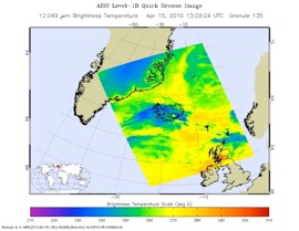 Image from AIRS infrared sensor, April 15, 2010. Image credit: NASA/JPL